|
It's the last day.
The weather forecast
says that
there may be early mist and fog patches
but these will disperse during the morning
and then on the whole it will be a dry day with bright or sunny spells.
...
Maximum temperature 19 degrees C.
Today, I'm walking just over 9 miles from Bradford on Avon to Bath.
As you can see from the map,
the canal meanders a bit:
it's a lot quicker as the crow flys.
There's a replacement bus service today
for the rail service between Didcot and Swindon.
I'm a bit unhappy concerning the 10 minute
and the 20 minute connections.
So I think I'll drive to Swindon.
I should do it in under an hour
and it'll cost 1.80 UKP to park in a long stay near to the
railway station.
(I think the car park at the railway station is about twice the cost.)
There's a lot on offer today:
Bradford Lock,
Avoncliff Aqueduct,
Dundas Aqueduct,
Somersetshire Coal Channel,
Claverton Pumping Station,
Sydney Gardens Tunnel,
Cleveland Tunnel,
six locks from Bath Top Lock down to Bath Bottom Lock,
including the deepest on the canal (Bath Deep Lock at 19'5"),
and
finishing with the
junction of the Canal with the River Avon.
The walk first returns the 0.3 mile from Bradford Railway Station to the canal at
Bradford Lock.
It's about 0.5 mile from there to
Bradford Swing Bridge.
This is what it looked like in 1977:
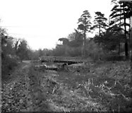
Bradford Swing Bridge, Kennet and Avon Canal
© Copyright Dr Neil Clifton and
licensed for reuse under this Creative Commons Licence.
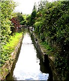
And then it's just under a mile to the first of today's aqueducts:
this first one is at Avoncliff:
Kennet & Avon Canal on Avoncliff Aqueduct
© Copyright P L Chadwick and
licensed for reuse under this Creative Commons Licence.
The canal then passes Limpley Stoke.
Wikipedia says that it
has two pubs, one of which, The Hop Pole,
was used in the filming of The Remains of the Day with Anthony Hopkins.
It also says that
Limpley Stoke's railway station (now closed)
was the junction station for the former branch line to
Camerton, Somerset, on which The Titfield Thunderbolt was filmed.
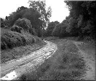
Kennet and Avon Canal, Limpley Stoke: canal bed under repair
© Copyright Dr Neil Clifton and
licensed for reuse under this Creative Commons Licence.
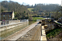
Then the canal crosses the River Avon and the railway by
means of Dundas Aqueduct:
Dundas Aqueduct
© Copyright Martin Clark and
licensed for reuse under this Creative Commons Licence.
Immediately at the western end of Dundas Aqueduct,
there is the junction with the
Somersetshire Coal Canal.
According to the Pearson Canal Companion, the
Somersetshire Coal Canal
was built to carry coal
from the colleries located south of Bath.
From Dundas it ran two miles to Midford
where it divided,
one arm extending to Radstock
and the other to Paulton.
Somerset Coal Canal viewed from Canal Basin
© Copyright Betty Longbottom and
licensed for reuse under this Creative Commons Licence.
The Milbrook Swing Bridge is about
0.5 miles north of the junction with the SCC.
This is what it looked like before restoration:
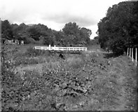
Kennet and Avon Canal: Milbrook Swing Bridge
© Copyright Dr Neil Clifton and
licensed for reuse under this Creative Commons Licence.
And here is a more recent photo:
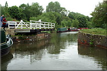
Kennet & Avon Canal, Milbrook Swing Bridge
© Copyright Pierre Terre and
licensed for reuse under this Creative Commons Licence.
It's about 0.5 mile
from Milbrook Swing Bridge
to the pumping station at Claverton.
A publicity leaflet produced by the K&A Canal Trust
says that the pumping station is
capable of pumping up to 100000 gallons
[of water]
an hour
from the ruver Avon
into the canal 48 feet above it.
The pump is operated by a giant waterwheel driven by the water itself.
The pump and waterwheel worked continuously
for some 140 years until 1952,
when a log trapped in the waterwheel caused some of the wooden teeth
on the 16 foot pitwheeel to be torn off.
The Wikipedia page for the pumping station says that
water is diverted from the river [Avon] by Warleigh Weir,
about 200 yd (180 m) upstream.
The water flows down a leat to the pumping station,
where it powers a water wheel,
24 ft (7.3 m) wide and 17 ft (5.2 m) in diameter,
with 48 wooden slats.
...
Each pump stroke raises 50 imperial gallons (230 litres) of water
to the canal.
The Pearson Canal Companion
explains that
whilst electric pumps do most of the work nowadays,
the water-wheels perform their ancient rites
on special days to an admiring public.
And one of those days is today.
So that'll be a treat.
It's about 1.75 miles from the pumping station to Bathampton.
There seem to be about three pubs at Bathampton.
That may be where I'll be getting lunch today.
And then it's about another 0.5 miles to Candy's Bridge:
Waterbus at Candy's Bridge, Kennet and Avon Canal
© Copyright Dr Neil Clifton and
licensed for reuse under this Creative Commons Licence.
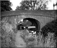
Things go quiet for about a mile.
Then there are a couple of short tunnels.
Here's one of them:
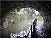
Tunnel entrance, Bath
© Copyright Roger Cornfoot and
licensed for reuse under this Creative Commons Licence.
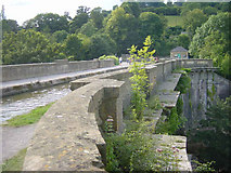
The canal will soon end and join the River Avon.
The end is not far from here.
However, the canal does not wimper out.
Instead, within its last 0.5 miles,
there are six aggressive locks.
There's Bath Top Lock (9'0"),
Pulteney Lock (9'5")
and Abbey View Lock (9'0").
Here's a photo of Abbey View Lock:
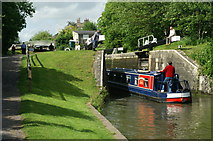
Abbey View Lock, Kennet and Avon Canal
© Copyright Pierre Terre and
licensed for reuse under this Creative Commons Licence.
Then there's Wash House Lock (8'6")
and Bath Deep Lock (19'5").
That is so deep.
It used to be the deepest in the UK,
but Tuel Lane Lock (at 19'8.5") on the Rochdale Canal now holds that honour.
Here's a photo from below Bath Deep Lock:
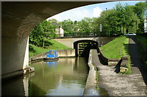
Below Bath Deep Lock, Kennet and Avon Canal
© Copyright Pierre Terre and
licensed for reuse under this Creative Commons Licence.
Here's a photo of an old GWR sign besides Pulteney Road:
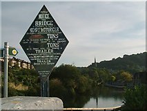
Old GWR Canal Bridge Sign, Pulteney Road
© Copyright mark harrington and
licensed for reuse under this Creative Commons Licence.
There's one more lock
which is Bath Bottom Lock (9'3")
and then my journey ends.
It ends
where the Canal joins the River Avon:
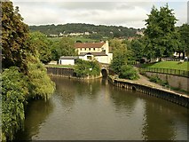
Start of Kennet and Avon Canal
© Copyright Derek Harper and
licensed for reuse under this Creative Commons Licence.
|