Forgot to say I saw a weasel/stoat yesterday. Not sure what the difference is between a weasel and a stoat. I'd only seen one once before. And again it was only for about 10 seconds. So no time for a photo.
But I do have a surprise in today's photos. No it's not another fox. But it's well worth waiting for.
I underestimated the time it takes to get to the High Street in Abingdon to catch the bus. So I was running for part of the way with a heavy rucksack and walking boots on. I got to the bus stop at 0817 for the 0820 bus to Wantage, and a driver of another bus said it had already gone and then I said it was meant to go at 0820 and he looked it up in the timetable he changed his mind saying it was probably hung up in traffic in Oxford. I couldn't decide which of his stories was correct.
I waited about 20 minutes. It didn't turn up, and so I thought it had already gone (early). Anyway, if it had not yet arrived, then with its late running I would miss my connection at Wantage to Childrey.
Whilst waiting I worked on plan B which was to catch the bus back to my place, drive my car to Wantage, take the 1030 bus to Childrey, do the walk (back to Abingdon) catch a bus to Wantage and then drive home. It's a bit silly but it looked like it would work, and it was not dependent on bus connections.
In Wantage, I stocked up at Waitrose with today's lunch: a cornish pie, a bag of crisps and chocolate cheesecake. And then caught the 1030 bus to Childrey. Eventually this had 8 old people who all knew each other, and it was quite a noisy bus with all the talking. Every time someone got on/off, there would be the hellos and goodbyes: I felt quite left out of it.
Except for 1 mile at the start and 1.5 miles at the end, the route for today follows the line of the old Wiltshire and Berkshire Canal. So it's northwards out of Childrey to find the Canal at West Challow. Although not marked on the adjacent map, the OS Explorer map implies that this section of the Canal has water in it.
Here is a link to today's photos.
I first saw the canal on the path from Childrey to West Challow (see photo). And the next two photos show it does have some water in it.
The photo at 1108 shows that in other places there is no water.
On approaching East Challow (which is on the second map below). I noticed people are filling the canal with their unwanted garden refuse (photo timed at 1123). And in East Challow many people have extended their gardens to the area occupied by the Canal (photo timed at 1124).
To the east of East Challow, stagnant water returns to the Canal (photo timed at 1133). There were coots in this water.
Just before Denchworth Road in Wantage, trees have been planted in the area which I think is that of the Canal (photo timed at 1146). Which, if true, seems a little silly.
On the other side of Denchworth Road, the path is full of stinging nettles (see photo). There's a road route that is just as quick and obviously everybody uses it because of the stinging nettles. Me too.
And just around the corner, adjacent to Mably Road in Wantage, I came across my first lock (see photos timed 1152 and 1153).
People dump stuff in the canal as this horrible photo at 1157 shows.
The Canal then goes alongside the southern outskirts of Grove and appears as the blue line that is just to the east of Grove on the second map to the right.Just north of Grove Bridge Farm the public right of way intrudes on several people's property. One woman asked me to wait before opening her gate so that she could put here two dogs inside. Here is a photo looking back towards some of the properties.
The next few photos show more locks and more refuse as the canal heads NNE away from Grove.
At one point near here, the footpath goes along the side of a field. It was only when leaving the field I saw a sign saying that a bull was present in the field! (See photo.)
The Canal then turns northeastwards making a bee-line for the Thames at Abingdon. Here there are places on the OS Explorer map where the line of the Canal is not marked in blue, and on the ground there is often little sign of the Canal. In some places the public right of way does not follow the Canal, and you have to go out of your way to rejoin the Canal at a later point.
This is the case near to Neville's Farm where you have to take a longer route whilst the Canal does about 2K. A farmer near to Neville's Farm said that the gate at the crossing across the railway line would be locked and if I were wanting to go that way I would have to climb the gate. The railway line is the main line from Paddington to Bristol. This is the same line as I saw yesterday. When I got to the crossing (see photo), the first gate was not even latched but the second gate was locked and it was easier to cross a side fence.
About 10 minutes later I stopped for lunch but storm clouds were brewing and it started to spit and so I skipped the cheesecake.
After lunch, I soon rejoined the Canal and almost immediately came across another lock (two photos at 1354).
Foolishly, at this point (SU429920), I chose to follow the canal NE-wards, even though the public right of way went SE-wards. Eventually the terrain got too tough and I had to return to the lock. I lost about 30 minutes doing this stupid move.
From the lock, the public right of way aims SE across a field to somewhere in a hedge. With the D'Arcy Dalton Way book, this would be easy as the author would give you a clue as to which way to walk. I nearly got my compass out, but in the end aimed about right and easily found the gap in the hedge which turned out to conceal a footbridge.
After walking for about a mile away from the Canal, I was nearing to returning to the canal when I spotted two deer (see lots of photos). One of these viewed me with a lot of suspicion and so I stood very still for what seemed like a long time. It went back to graze, then quickly looked up: I was still frozen. About three minutes later when it was really grazing, I gradually moved forward. And then at 1440 something scared the other deer. I don't think it was me. And off they went. I got two reasonably good photos of them bounding across the grass.
At Cow Common, there is no sign of the Canal: it is a mud track with some soil engineers drilling nearby.
As I cross the Steventon Road, it started to rain quite hard and so I put on a few more layers. Needless to say, it didn't last long. But threatened time and again all afternoon.
Just SW of Willow Bank Farm, there is a sign indicating the site of Steventon Lock (see photo) and a hole showing some evidence of it (see another photo).
Near to Drayton Copse, there is another lock called Drayton Lock. My photo was taken at 1528.
There was a person lurking around the Lock which scared me a bit but he was probably another soil engineer as they seem to have another drilling site not far away.
Anyway, at this point I unknowingly veered 60 degrees away from the route of the Canal and followed another footpath. Believe it or not, it wasn't for another 3 miles before I knew that I had done this! All I can say is that because of the dense undergrowth it's hard to have a clear picture of what is happening around you. It's a poor excuse.
So off I went eastwards instead of NE-wards. Didcot Power Station was visible almost ahead of me (see two photos). That should have given me warning signs. That should have told me I was walking the wrong way.
Along this footpath I saw an enormous mushroom/toadstool (see photo).
It was when I reached the A34 I knew something was up. And when I saw the housing of Drayton I worked out from the map where I was.I walked onto the main street of Drayton. I was most annoyed. I consulted the timetable at a bus stop for the bus back to Abingdon. There was a bus in 15 minutes time. I walked with my tired feet along the uncomforting tarmac a bit further. I decided to go back to the bus stop via the pub and catch the bus back to Abingdon. After a few minutes of walking back, I thought I can't do a circular walk from Abingdon and not finish the last segment. So I turned around and walked on.
On consulting the map, I discovered I could avoid some of the tarmac of the route back to Abingdon by walking (out of my way) back towards the Canal. This would take me to New Cut Mill where the Canal and the River Ock are close together. I believe there is a Lock here but when I got there I saw no evidence of it.
En route I saw a rabbit (two photos).
The large bushes and trees in the next photo (taken at 1710) show the line of the Canal to the NE of New Cut Mill.
In South Abingdon, the Canal goes through a housing estate. In the first photo, the Canal goes from left to right with an electricity substation in the way. The second and third photos show the public right of way going between people's properties and the enormous amount of stinging nettles, undergrowth and refuse demonstrate no-one walks this route. Sorry, the third photo should have been rotated by 90 degrees.
The next photo (taken at 1725) shows the line of the Canal goes along Caldecott Road in South Abingdon.
The final photo shows the River Ock in Abingdon. It is considerably wider here than it was in the photo I took yesterday of the Ock near to the village of Longcot.
If you go along the Thames Path, you will see that there is a Wilts and Berks Canal sign at the point where the Canal used to join the Thames. As the previous photos have shown, the current line of the Canal goes through a lot of housing in South Abingdon. The people proposing the restoration of the Canal have a sign up on the Thames showing where they propose the new junction of the restored Canal. This would be near to where the Culham Cut joins the Thames. However, I don't know how they plan to cut across country to the line of the old Canal, and if they were to work across to the Lock at New Cut Mill, there would be a 90 degree turn in the Canal at this point.
Anyway, from what I've seen today there would be an enormous amount of work to restore the Canal.
It was a long day. And I did quite a few extra miles which I've not yet added to the table. To add to this, the bus back to Wantage was 23 minutes late. Another passenger said it was often this late, and that sometimes it didn't turn up.
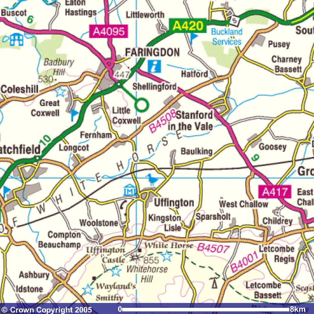
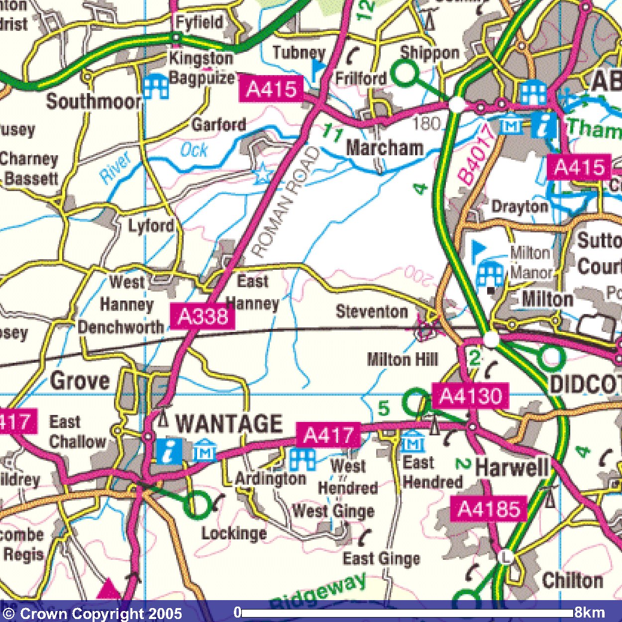
Images produced from the Ordnance Survey Get-a-map service.
Images reproduced with kind permission of Ordnance Survey
and Ordnance Survey of Northern Ireland.