|
Today's walking is from Kintbury to Great Bedwyn.
Like yesterday, both places have raliway stations that are close to the Canal.
To save hassle, I'll aim for the 1537 train home. That'll mean getting the
0827 train on the way out and that'll require an Anytime Return.
Today there is just 7.75 miles of walking with about 100 feet of ascent
visiting locks 78 to 65.
I don't quite get to the top today:
that treat is in store for tomorrow.
Today's plan is walk the
3 miles to Hungerford
and have a coffee;
go the 2 miles to Froxfield
and have lunch;
and finally do the
2.75 miles to Great Bedwyn.
There are four locks on the way to Hungerford.
The deepest is Wire Lock (at 6'10").
Here's a photo of it:
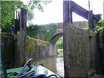
Kennet and Avon Canal east of Hungerford 6
© Copyright Jonathan Billinger and
licensed for reuse under this Creative Commons Licence.
On the other side of Hungerford,
there is a weird swing bridge:
it's weird because it straddles a lock.
When on a boat,
it will get you to think a bit more about the order
in which to do things!
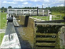
Marsh Lock, number 73
© Copyright Graham Horn and
licensed for reuse under this Creative Commons Licence.
The
www.geograph.org page says
this is an unusual but logical arrangement
where the swingbridge goes over the lock,
thus saving the boatmen from stopping twice.
Just remember to open the swingbridge before you fill the lock.
It is necessary because a number of footpaths converge here,
from various parts of the surrounding common land, Freeman's Marsh.
It's about 2 miles from Hungerford to Froxfield.
The plan is to go to the Pelican at Froxfield for lunch.
The Nicholson Guide says that
the pub is just
two minutes' walk from the canal.
Real ales and food available
with Scotch steaks and fresh fish a speciality.
I couldn't find any web pages for the pub
but there are two reviews:
one is from
www.thisiswiltshire.co.uk
and the other is from
www.tripadvisor.com.
The Pelican is on the A4.
This is the original Bath road. It has been less than a mile
away from the Canal for all of the trip from Kintbury to Froxfield.
However, at this point the A4 and the Canal part company
as the Canal turns from its Westerly heading to go South.
The reason for this will be come clearer tomorrow:
it's all to do with how to cross the top of the hill
that looms ahead.
The Canal from here westwards to beyond Bradford on Avon
is documented mile by mile in great detail and with lots of photos
in the
Kennet & Avon Scrapbook 2000.
For example, here is the Scrapbook's photo of the bridge at
Froxfield:

I plan to do the remaining 2.75M
(from Froxfield to Great Bedwyn)
after lunch.
Just after Froxfield, there are three locks in a row.
Here's a photo of the first of these:
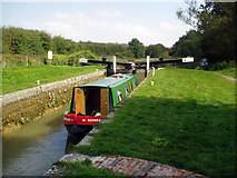
Ascending Froxfield Bottom Lock No 70, Kennet and Avon Canal
© Copyright Dr Neil Clifton and
licensed for reuse under this Creative Commons Licence.
After those three, there are three more locks on the way to Great Bedwyn.
Here's a photo of the last lock of the day:
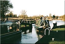
Burnt Mill Lock - No.65 - Great Bedwyn
© Copyright Maurice Pullin and
licensed for reuse under this Creative Commons Licence.
And I leave the Canal (to go to the Railway Station)
using Bedwyn Wharf Bridge:
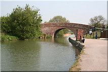
Bedwyn Wharf Bridge, Kennet and Avon Canal
© Copyright Dr Neil Clifton and
licensed for reuse under this Creative Commons Licence.
One of the attractions of Great Bedwyn is
its
Stone Museum.
Here is a link to
Ed Buziak's web page describing the Gt. Bedwyn Stone Museum.
He says that the one name synonymous with stonemasonry
in Wiltshire is Lloyd. For over 200 years the same family have been cutting,
chiselling, carving and creating with stone in Great Bedwyn,
a quiet village straddling the Kennet and Avon Canal.
Here are two photos of parts of the museum:
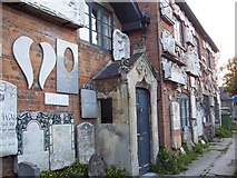
Stonemason's Museum, Great Bedwyn
© Copyright Trish Steel and
licensed for reuse under this Creative Commons Licence.
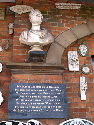
The photo was taken by
Anguskirk
and is licensed with a
Creative Commons
license.
| 


